Resources
Fact Sheet
SR-84 Intermodal Bus Facility Fact SheetFrequently Asked Questions
The proposed SR-84 Intermodal Bus Facility (Project) would promote and improve multimodal Transbay travel and connectivity. Combined with other regional transit efforts, like the South Bay Connect project, improved Transbay bus and private shuttle service connectivity from Alameda County to the Peninsula will support the transportation needs of our growing region.
The Capitol Corridor Joint Powers Authority (CCJPA), the project sponsor, is working in partnership with the California Department of Transportation (Caltrans), the lead agency for the environmental process.
The Project is located on the SR-84 corridor situated between the cities of Newark and Fremont. The elevated bus facility would be built on a section of SR-84 east of Paseo Padre Parkway interchange and east of the Lake Boulevard overcrossing of the Union Pacific Railroad Coast Subdivision (just south of the Ardenwood Park-and-Ride facility). See project area map.
- Heavy traffic congestion on SR-84 caused by overcapacity conditions at the Dumbarton Bridge approach and traffic signal delays
- Delayed Transbay buses and employer shuttles have longer travel times as they follow a roundabout way to reach the congested Ardenwood Park-and-Ride
- A more efficient multimodal connection is needed to improve travel times of Transbay bus and shuttle services and encourage a shift from car to bus and rail
- Improved transit connectivity between Alameda County and the Peninsula in San Mateo and Santa Clara counties
There are two proposed alternatives. Alternatives 1 and 2 both would:
- Improve travel times for buses and shuttles along SR-84
- Encourage mode shift from single-occupant vehicle travel
- Promote and improve multimodal Transbay connectivity
Alternative 1
Highway Median Bus Stop with Center Platform
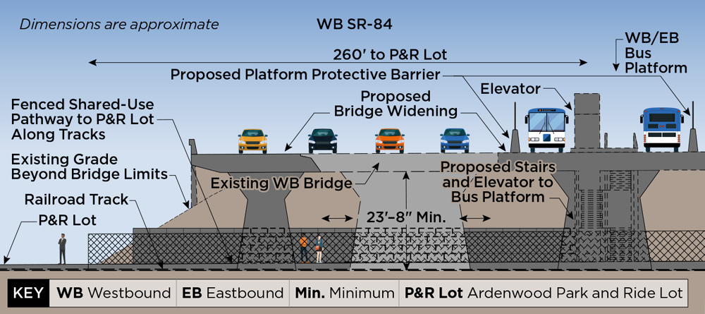
This alternative has a bus stop with a center platform in the median of SR-84 that would serve both eastbound and westbound buses. Bus-only lanes would be constructed in the median to connect to this new stop. From the bus stop, passengers would access the Ardenwood Park-and-Ride via elevators, stairs, and/or ramps to a shared-use pathway below SR-84. The existing highway (including bridges) would be widened to meet Caltrans standards for traveled lane and shoulder width.
Alternative 2
Highway Median Bus Stops with Outboard Platforms
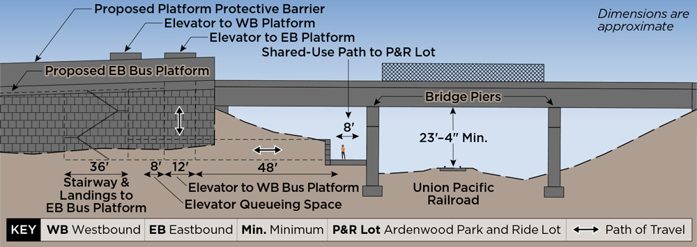
This alternative would construct two bus stops, each with an outboard platform, in the median of SR-84 to serve eastbound and westbound buses. Bus-only lanes would be constructed in the median to connect to these new stops. Passengers would access the Ardenwood Park-and-Ride from these bus stops via elevators, stairs, and/or ramps to a shared-use pathway below SR-84. The existing highway (including bridges) would be widened to meet Caltrans standards for traveled lane and shoulder width.
CEQA is a California statute passed in 1970 shortly after the federal government passed NEPA which established national environmental policy and goals. CEQA institutes a statewide policy of environmental protection. The purpose of CEQA and NEPA is to publicly disclose any significant environmental effects of a proposed project through the preparation of, in this Project’s case, an environmental document called an Initial Study/Environmental Assessment (IS/EA). Because this project is both state and federally funded, the environmental process must follow both laws.
The National Environmental Policy Act (NEPA) is a landmark United States federal law established in 1970. NEPA mandates that federal agencies must assess the potential environmental impacts of their proposed actions, including major projects, policy changes, or regulations. It requires agencies to consider alternatives, involve the public in the decision-making process, and issue environmental impact statements to inform the public and decision-makers about the environmental consequences of their actions.
The IS/EA as required by CEQA/NEPA, analyzes Project alternatives for potential environmental impacts. It reviews a wide range of resource areas to identify potential impacts and establish clear mitigation actions prior to project approval. To learn more about each step of the process and public comment opportunities, please visit the Environmental page.
Key activities include, but are not limited to:
- Environmental data collection and field surveys
- Preparation of environmental technical studies
- Development of a Draft IS/EA
- Public review of a Draft IS/EA
- Preparation of final environmental approval documents
The public is invited to participate in upcoming public outreach activities to learn more about the two Build Alternatives being proposed. Event information can be found here. Members of the public, interest groups, and state and federal agencies are invited to participate and provide public comments to the Draft IS/EA when released in 2026. The public can also join the email notification list by filling out the online form here.
The Project team is currently conducting public outreach to spread awareness about the Project and the two proposed Build Alternatives. To learn more about events, visit here. The Project team will continue public outreach when the Draft IS/EA is released in 2026.
You can stay informed by joining our email newsletter list via the Comment Form!
Environmental Documents & Reports
There are currently no environmental documents and reports available. Please check back later.
Project renderings & Images
Alternative 1
Median Bus Stop
Cross-Section View — Preliminary Concept Design Only
Alternative 1
Median Bus Stop
Profile View — Preliminary Concept Design Only
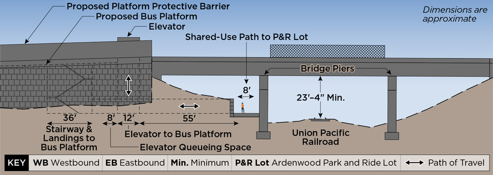
Alternative 2
Split Bus Stop
Cross-Section View — Preliminary Concept Design Only
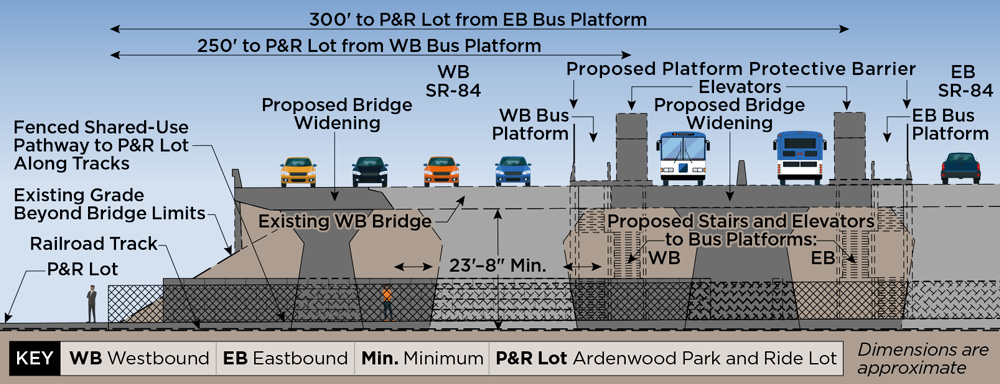
Alternative 2
Split Bus Stop
Profile View — Preliminary Concept Design Only