An animated GIF that shows the two design alternatives for SR-84 intermodal bus facility. It has moving cars, moving busses, and changes of where the bus platforms are located per alternative design 1 and design 2. It is on a loop.
Animation graphic not to scale for imaging purposes only

SR-84 Intermodal Bus Facility

The State Route 84 (SR-84) Intermodal Bus Facility Project is proposed by Capitol Corridor Joint Powers Authority (CCJPA) in partnership with the California Department of Transportation (Caltrans). The bus facility would enhance Transbay bus and shuttle service connections from Alameda County to the counties on the San Francisco Peninsula and build upon other regional transit efforts that promote and encourage multimodal access and connectivity.

Overview

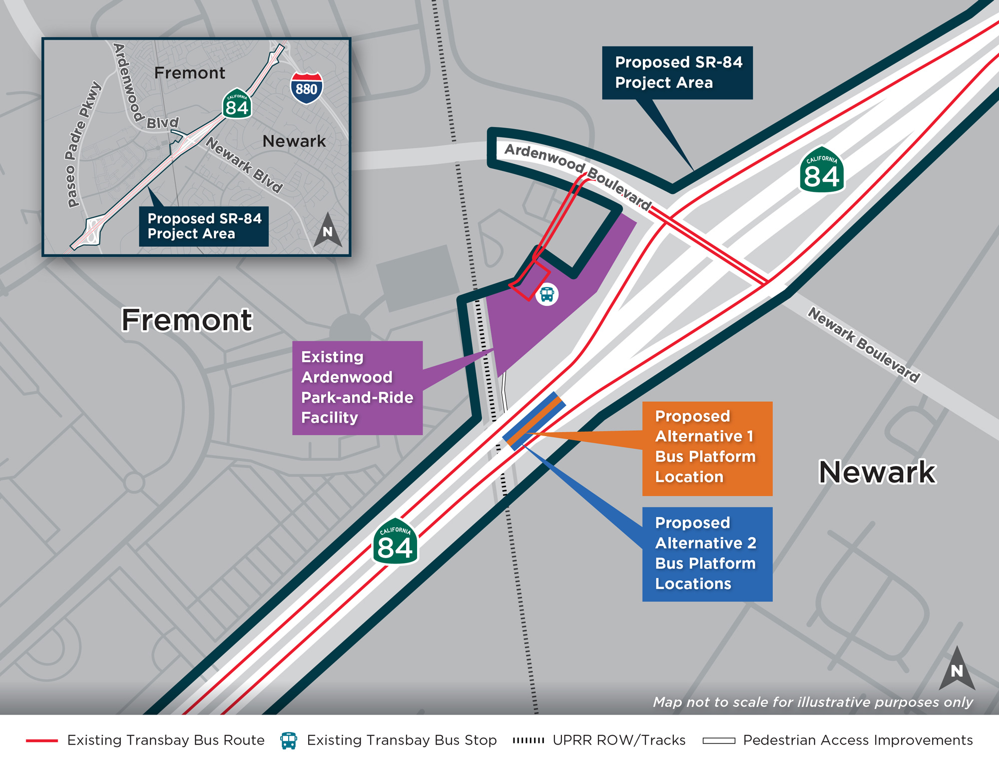
The SR-84 Intermodal Bus Facility Project’s (the Project) proposed location is on SR-84 adjacent to the existing Ardenwood Park-and-Ride, on the border between Fremont and Newark. The Project is being designed to:

  • bus icon Connect transit and private employer shuttle services with future improvements at the Ardenwood Park-and-Ride
  • bus over bridge icon Allow buses and shuttles to pick-up and drop-off passengers at an elevated highway level for improved operational efficiency
  • stopwatch icon Create a more direct route at the Ardenwood Park-and-Ride entrance/exit to reduce congestion and travel time

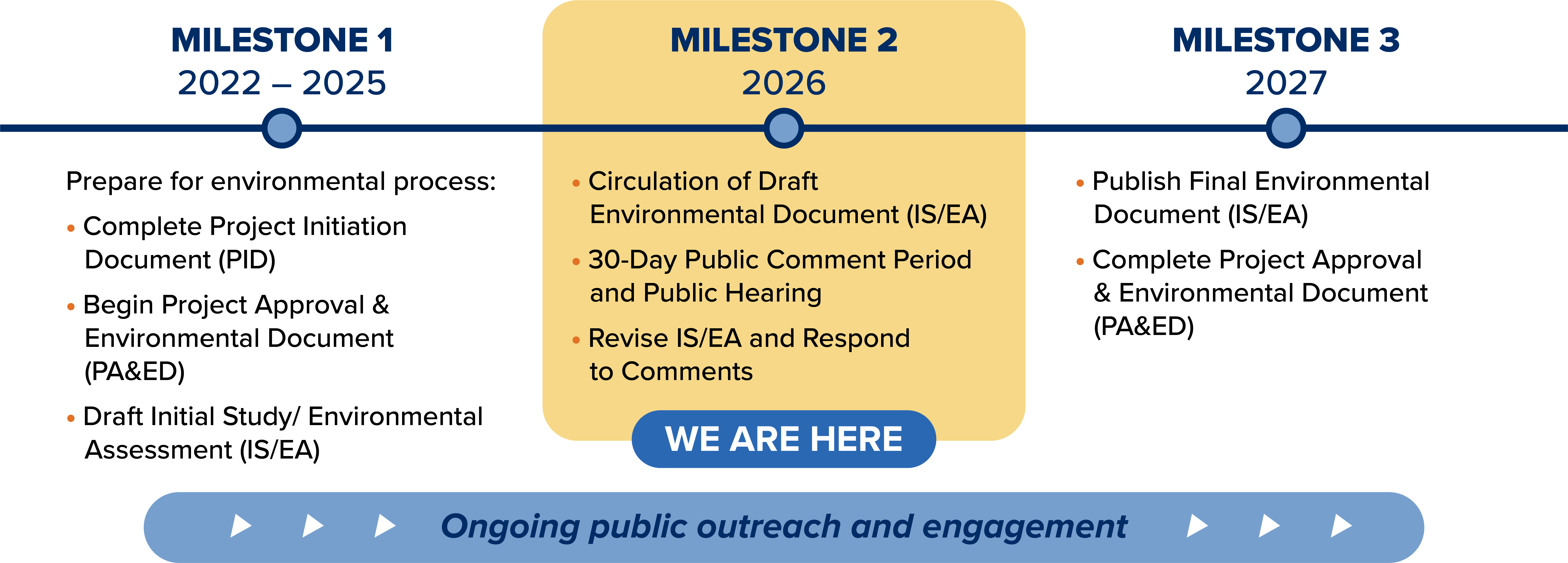
Caltrans is the lead agency for California Environmental Quality Act/National Environmental Policy Act (CEQA/NEPA) compliance. Visit the Environmental page for more details. CCJPA is the sponsor agency of the Project.

This is a map that shows the project area in relation to the broader areas of The San Mateo Bridge, Union City, Fremont, Newark, and East Palo Alto. The project area is shown with a star symbol on the eastern part of the Dumbarton Bridge.

Project Benefits

Connecting public transit and private employee shuttle services with future transit improvements, like the Capitol Corridor South Bay Connect Project, at Ardenwood Park-and-Ride will deliver the following benefits:

stop watch animation

Improve Access, Reliability & Travel Times for Regional Buses

car to bus animation

Encourage the Shift from Car to Bus & Rail

stop watch animation

Promote & Improve Multimodal Transbay Connectivity in the Area

Linking Alameda County to Peninsula Counties with Improved Transbay Connectivity

Project Area Map

Facility Design

Two design alternatives are being studied for the SR-84 Intermodal Bus Facility:

1 Alternative 1 Highway Median Bus Stop with Center Platform

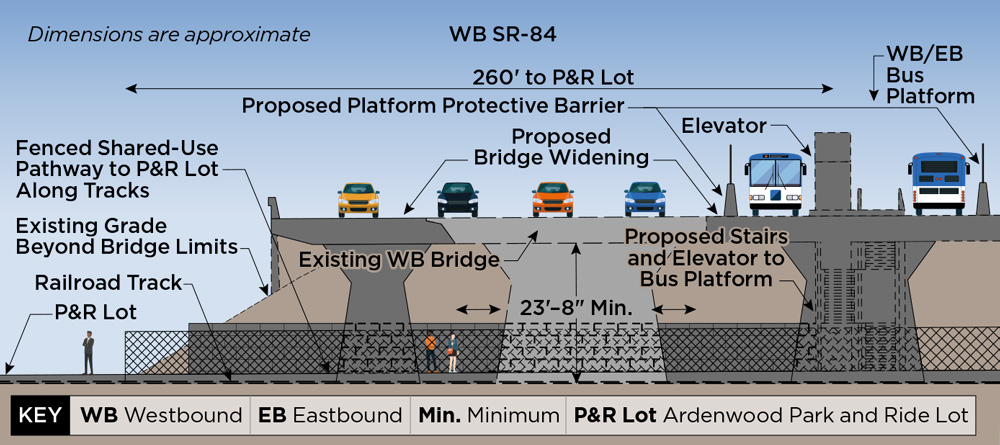
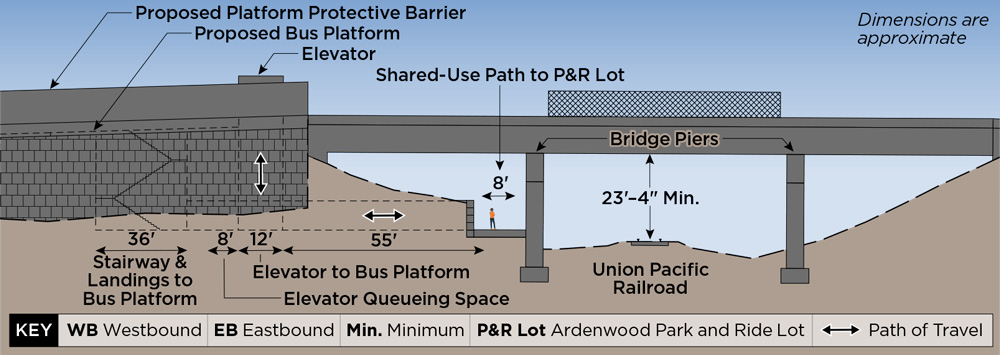
This alternative has a bus stop with a center platform in the median of SR-84 that would serve both eastbound and westbound buses. Bus-only lanes would be constructed in the median to connect to this new stop. From the bus stop, passengers would access the Ardenwood Park-and-Ride via elevators, stairs, and/or ramps to a shared-use pathway below SR-84. The existing highway (including bridges) would be widened to meet Caltrans standards for traveled lane and shoulder width.

A Birds Eye View animated GIF shows east and westbound buses/shuttles stopping at a median platform between the existing SR-84 travel lanes. This is called Alternative 1 Median Bus Stop.
Bird’s-Eye View
This cross-section schematic shows features and measurements of the proposed Alternative 1. The distance from the elevator to the platform (125 feet), Ardenwood rail platform and the height from the rail to the platform (23 feet and 8 inches), the fenced pathway to rail platform along the tracks, proposed stairs and elevator to the West and Eastbound bus/shuttle platforms.
Cross-Section View — Preliminary Concept Design Only
Profile View
Profile View — Preliminary Concept Design Only

2 Alternative 2 Highway Median Bus Stops with Outboard Platforms

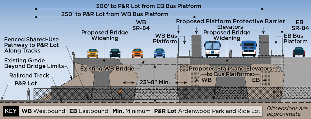
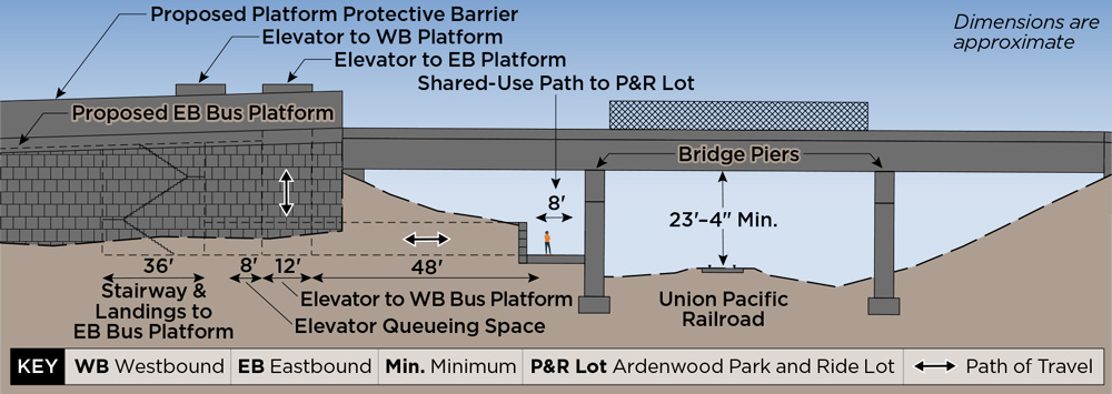
This alternative would construct two bus stops, each with an outboard platform, in the median of SR-84 to serve eastbound and westbound buses. Bus-only lanes would be constructed in the median to connect to these new stops. Passengers would access the Ardenwood Park-and-Ride from these bus stops via elevators, stairs, and/or ramps to a shared-use pathway below SR-84. The existing highway (including bridges) would be widened to meet Caltrans standards for traveled lane and shoulder width.

A Birds Eye View GIF shows westbound buses using a platform on the shoulder of SR-84, and eastbound buses using a platform in the median. This is called Alternative 2 Split Bus Stop.
Bird’s-Eye View
This cross-section schematic shows features and measurements of the proposed Alternative 2. The distance from eastbound buses to the platform (86 feet) and then from the platform to rail (47 inches). On the left it shows a westbound bus platform , and the proposed stairs and elevator that riders can use. On the right, it shows the eastbound bus platform, and the proposed stairs and elevator. It shows the Ardenwood rail platform and the height from the rail to the platform (23 feet and 8 inches), the fenced pathway to rail platform along the tracks.
Cross-Section View — Preliminary Concept Design Only
Profile View
Profile View — Preliminary Concept Design Only

Project timeline

2022

Fall

  • Complete Project Initiation Document (PID)
  • Begin Project Approval & Environmental Document (PA&ED)

2023

2024

2025

Spring

  • Public Meeting
  • Draft Initial Study / Environmental Assessment (IS/EA)

2026

Late Spring – Early Summer

  • Circulation of Draft IS/EA

Summer

  • Public Meeting

2027

Late Spring

  • Final IS/EA

Early Summer

  • Complete Project
    Approval & Environmental
    Document (PA&ED)